
Starlink is satellite internet, using a dish on the ground to communicate with a constellation of thousands of satellites orbiting the Earth. With Starlink, you need a clear view of the sky to get reliable service. If there are trees or buildings blocking the view of the dish, you can experience interruptions. Starlink refers to these objects as obstructions.
The Starlink app is your command center. You’ll find the status of your dish and router, as well as several different settings and options. One of the tools in the app is the obstruction map. The obstruction map allows you to see any potential objects that might be causing interruptions to your internet service.
The map is created as the Starlink satellites orbit overhead and communicate with your dish. Each time your dish talks to a satellite, it records where the satellite was, and how long the interaction lasted. Successful interactions are marked blue based on where they occurred in the sky, relative to your dish. Interrupted communications are marked red, which can indicate obstructions.
Related: Starlink Obstructions, How Much Is Too Much?
One question I see frequently is in regards to an area or line that appears to be blank on the obstruction map. The rest of the map is blue, but there is a clear line that is neither red or blue. Since black areas represent “no data” according to the map legend, people often wonder if their dish is broken, or if it’s a concern. Here is an example of what it looks like:
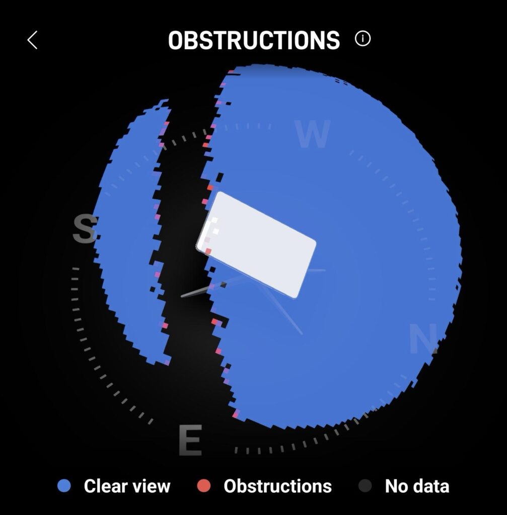
The blank line in the obstruction map represents the Clarke Belt, which is a collection of satellites in geosynchronous orbit. There are many satellite systems in geosynchronous orbit, like those used by satellite TV providers. In a geosynchronous orbit, the satellites are stationary relative to the Earth. If you were to look up in the sky at any moment during the day, the satellite would be in the same place. The satellites in the Clarke Belt orbit above the Earth’s equator.
To learn more about geosynchronous orbit and the Clarke Belt, I recommend reading this Wikipedia page.
Starlink satellites don’t use a geosynchronous orbit. Instead, they are in low Earth orbit. Their altitude is much lower than many satellites in geosynchronous orbit. Starlink satellites are constantly moving relative to the Earth. On the ground, it would look like they are flying across the sky. Instead of following the equator, the Starlink constellation of 5,000+ satellites moves all over the sky, creating a mesh grid of coverage.
To avoid interfering with satellites orbiting in the Clarke Belt, Starlink doesn’t allow dishes on the ground to communicate with that area of the sky. Each Starlink dish can accurately calculate its position on Earth. It uses that data to avoid communicating with Starlink satellites that are in the same direction as satellites in the Clarke Belt.
The closer your dish is to the equator, the more noticeable the Clarke Belt exclusion area will be on your Starlink obstruction map. People living in the US, for example, are generally too far North to see the exclusion zone show up on their map. But in locations closer to the equator, you will see a blank band representing the Clarke Belt, where Starlink isn’t allowed to transmit signals to from dishes on the ground.
Don’t worry, the presence of the Clarke Belt doesn’t have any effect on your Starlink internet performance. There are plenty of other satellites orbiting overhead. At any one time, your dish can see multiple satellites, thanks to the wide field of view of the electronic phased array antenna. Starlink programming takes the Clarke Belt into account, so people living near the equator will have a seamless experience, even with an area of the sky seemingly missing.