
The Starlink Obstruction Map Now Updates In Real Time, Shows Satellite Paths
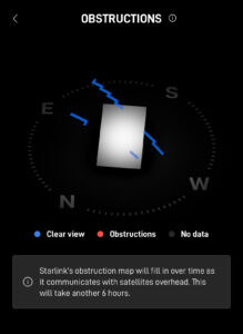
Starlink has updated the obstruction tool in the app to display real time information and satellite paths. Previously, the obstruction tool needed about 12 hours of data collection, before obstruction information could be displayed. Now, information is available immediately after the dish powers on. The obstruction map will update in real time, for about 6 hours after the dish boots up. If you’ve looked at your obstructions recently, you may have noticed the change already. The shaded areas of blue and red on the map are now more pixelated, and may not look as filled in as before. With the …